(To read the first part of this trip, click here!)
After a good night’s sleep, my altitude sickness had (thankfully) worn off and I was ready to greet the morning in Tagong! Others on my trip were not so lucky, unfortunately, and felt sick sometimes for days at a time. Understandably so – the Tibetan Plateau is the largest and highest plateau in the world, with an average elevation of 14,800 feet/4,500 meters!
塔公 Tagong (or, in Tibetan, ལྷ་སྒང་། Lhagang) is a small town in the Garzê Tibetan Autonomous Prefecture of the western Sichuan Province of China, in the historical Kham region of Tibet. (Rightful Heir to the Iron Throne, Rightful Queen of the Andals and the First Men, Protector of the Seven Kingdoms, Mother of Dragons, Khaleesi of the Great Grass Sea, the Unburnt, the Breaker of Chains… I know it can feel like a lot of confusing names and titles associated with each of these regions, but I think it’s important to acknowledge. These places I’m visiting and learning about have a long and complex history often spanning multiple cultures and ethnicities, and dating back – according to some scientists – nearly 60,000 years. I would be remiss not to try to provide a bit more context!) The region of ཁམས་ Kham is quite diverse, and spreads across three Chinese provinces (western Sichuan, southern Qinghai, and northwest Yunnan) and the eastern portion of the Tibetan Autonomous Region. From mountains to grasslands to rivers and lakes, it is a stunning part of the world to travel through – if you’re going to spend multiple hours on a bus each day, you can’t find a much better place to do it! The people of Kham are known for primarily living as farmers and nomads, herding thousands of yaks through the grasslands; historically, they also have a reputation as the warriors of Tibet: brave, fierce horseman who defended their land against outsiders and endured incredibly harsh environments.
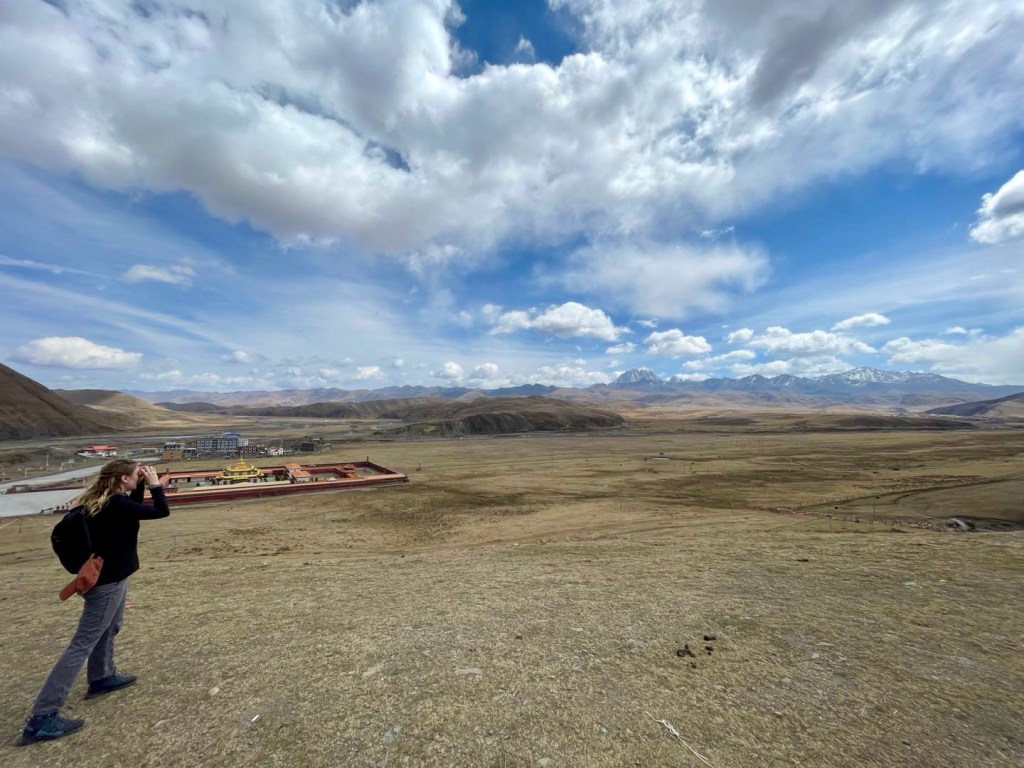
Tagong itself is a pretty small town in the middle of a vast grassland, but is a very special place. The name Tagong translates literally to “the land favored by Bodhissatva” and has a local legend to accompany it:
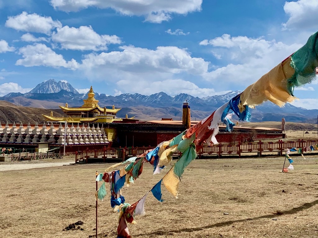
In 640 AD, the Chinese Princess Wencheng left her home in Chang’an (modern day Xi’an) to make the 2,000 mile journey to Lhasa to marry the Tibetan King and founder of the Tibetan Empire, Songsten Gampo. With her, she brought what was to be a gift for her future husband: a life-size statue of 12-year old Shakyamuni Buddha. However, when the Princess was traveling through Tagong, this statue – known as the Jowo Shakyamuni – grew heavy, fell to the ground, and refused to move. The Jowo Shakyamuni then spoke, saying that it loved this place and wanted to stay. Because this statue was meant to come with the princess on to Lhasa, Princess Wencheng asked her craftsmen to create a second statue identical in every way to the Jowo Shakyamuni. Once the second statue was completed and left in Tagong, the Jowo Shakyamuni agreed to be moved again, and continued on to its final home. Now, it is said that if you cannot go to Lhasa for Pilgrimage, you can instead visit the Jowo Shakyamuni statue in the Tagong Monastery and worship the Buddha there.

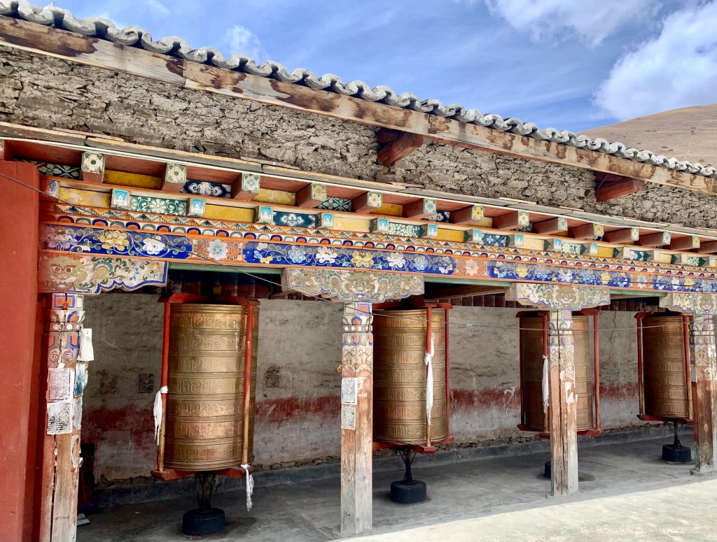
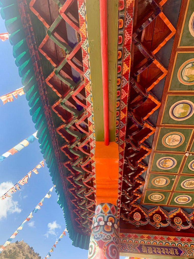
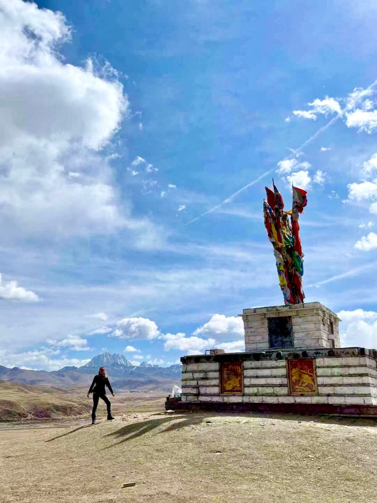
Though I’d been to Jing’an Temple in Shanghai (I live only a few blocks away from it!), the Tagong Monastery was unlike anything I’d ever seen before. As when I visited Kangding, one of the first things that stood out to me was the vibrancy of all of the color. Color everywhere! In Tibetan Buddhism, colors have specific meanings and significance. One example is seen in the Tibetan prayer flags I saw dancing in the wind all around the monastery. Prayer flags are put up not to ask for self-serving wishes or desires, but to pray for good blessings for the world – it is said that when the flag is being hit by the wind, the wind carries the prayers and good wishes along with it. The five colors seen on the Tibetan prayer flags represent the following:
Blue (sky/heavens) : purity and healing
White (wind/air) : learning and knowledge
Red (fire) : life force and energy
Green (nature/water) : balance and harmony
Yellow (earth) : rootedness
We were asked not to take any pictures inside the temples out of respect, but luckily I always travel with a little notebook for moments such as these and was able to do a quick, rough sketch of some of the beautiful statues inside. I really enjoy pulling my notebook out while traveling. Though I’m by no means a great visual artist with a pencil in my hand – I’m very much a doodler – taking the time to look back and forth between my notebook and what I’m seeing, paying attention to little details and trying to capture them, it all feels really special to me. Like I’m able to have my own silent conversation with this beautiful sight. (Tangent: I wish I could say everyone in my group respected the “no pictures” request, but they did not. If you are asked not to take pictures, DON’T TAKE PICTURES. I don’t care if it’s quick, I don’t care if it’s sneaky, I don’t care if you don’t see the big deal, I don’t care if no one stops you. Coming in as an outsider and being shown this incredibly sacred thing, having this part of someone’s culture shared with you; for you to just disrespect their wishes for your own wants? Not a good look. Don’t do it.)
My other favorite part of the monastery was the sand mandala that some of the monks were creating. (I, again, don’t have a picture, but feel free to search for some online – they are truly stunning.) Meant to represent the universe, sand mandalas are made using intricate geometric shapes and patterns, each created out of carefully placed, colored sand. The mandala that was being worked on when I was there was only about halfway completed – creating these pieces of art can take weeks at a time, and require an incredible level of patience and concentration! The thing about sand mandalas that really moved me is that once they are completed – after the countless hours of work that have been put into them – they are destroyed. The sand is swept into a nearby river, where it is believed the river will carry the blessings of the mandala away with it. This is meant to represent the impermanence of all things; nothing gold can stay, right, Ponyboy?


After walking through the monastery, we hiked up a nearby hill to get a better view of the 塔公草原 Tagong Grasslands. The Grasslands cover over 700 square kilometers, and are home to many Tibetan nomads and herdsmen. In the distance, we were able to see Mount Yala; this mountain is covered in snow all year round, and is worshipped by Tibetan people as the area’s patron saint.

We then hopped back on our bus, and headed off to our next destination: 道孚县 Daofu (རྟའུ་རྫོང Dawu), a county known for its Tibetan folk houses, wood working, agriculture, and love of horses. Our local guide, who is originally from this county, jokingly told us all that contrary to popular belief, though the people from Daofu love their horses, they do not eat their horses. He had a good laugh telling us that!
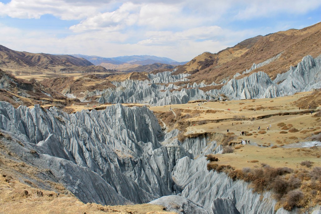
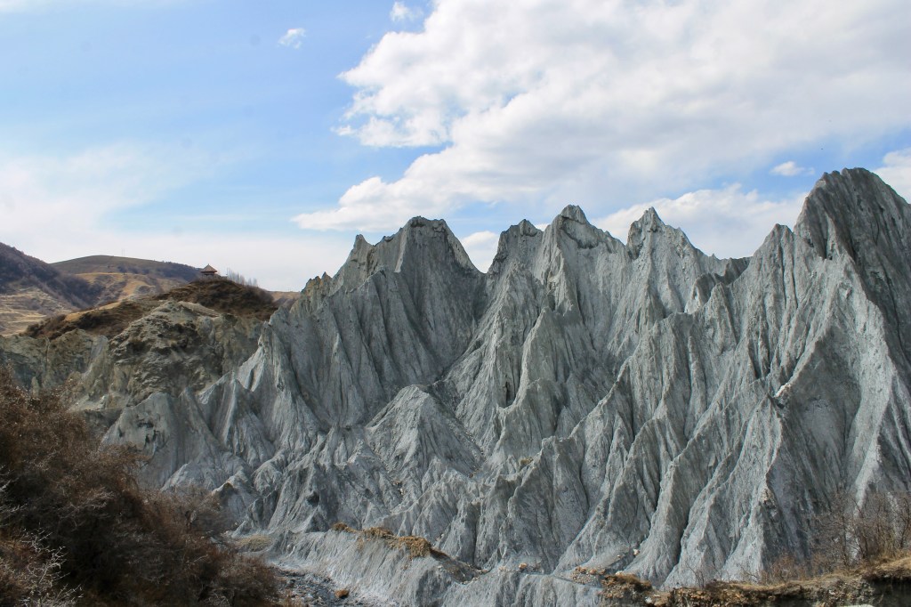
That afternoon we arrived in 八美镇 Bamei Town (for reference, this “town” covers 281 square kilometers and has a population of 0.5 million – it may be more helpful to think of it less as a town, and more as a region with lots of little villages scattered throughout the mountains) within Daofu County, and set off to see one of Bamei’s biggest attractions: 墨石公园 Moshi Park! Originally called the 八美石林 Bamei Stone Forest, Moshi Park (the Mandarin translates into “ink stone public garden”) is an amazing natural phenomenon – in the middle of all of this grassland, a “forest” of mylonite jutting up from the ground! When approaching China’s only plateau stone forest, it feels as though you’ve suddenly been transported on to another planet. I’m sure there is some very interesting scientific reason for Moshi Park’s formation, but making myself understand it would take another hour or so of research, and I’ve already spent over 5 hours on this post. (Sorry to my brother and any other geology nerds – something to do with tectonic movement, fracture zones, the uplift of the Tibetan Plateau, erosion, mylonite, and…… thousands of years ago. That’s all I’ve got for you.) As a consolation, a different cool science fact: because the mylonite in the stone forest contains calcium salts, the color of the rock changes based on the humidity. The rocks appear to be a light blueish gray in dry seasons, and turns the color of ink when in the wet season. Hence, the name: Inkstone!


After a few hours hiking around Moshi Park (definitely pretending to star in some sci-fi action movie the entire time, I won’t lie) we went back to our hotel and I promptly fell asleep. To be honest, I don’t even think I ate dinner that night, I was so tired. (This entire blog post covered one day. So… we kept busy.) Stay tuned as I attempt to finish these Sichuan spring break posts before I leave for my next adventure in 9 days… Will she make it? Tune in next time to find out!

Thanks once again, Madie, for sharing your amazing journey! The respect you show for those in whose land you’re visiting speaks volumes to your stellar global character. I so appreciate your detailed descriptions and beautiful pictures. May you continue to be blessed!
LikeLiked by 1 person
Oh, thank you! I’m learning so much about different cultures as I’m out here exploring, and one of the main reasons I wanted to blog while over here was to allow people to get a glimpse into a part of the world they may never get to experience on their own. Or, even better, to encourage them to visit it themselves! 🙂
LikeLiked by 1 person
Loving my “armchair travels” with Madie! Thanks for sharing.
LikeLiked by 1 person